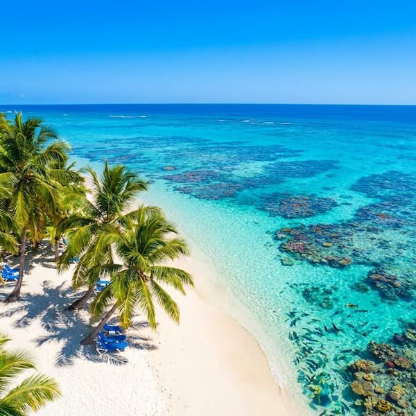
West Coast: The Platinum Calm
On the Caribbean side of the island, the water remains famously tranquil, providing conditions ideal for snorkeling and swimming. A series of offshore reefs acts as a natural buffer, absorbing the energy of the sea and creating a mirror-like surface for the majority of the year. This is the region where families typically choose to stay if their primary holiday objective is gentle immersion in the water.
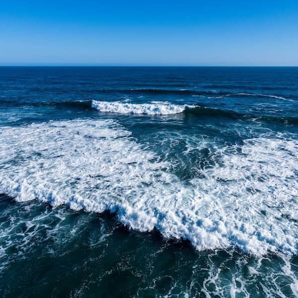
East Coast: The Atlantic Power
As you move toward the parish of St. Philip and Bottom Bay, the geography shifts fundamentally. Here, the Atlantic Ocean brings raw energy, massive swells, and powerful undercurrents that demand significant respect from every visitor. The protection of the reef disappears, leaving the shoreline exposed to thousands of miles of open ocean. Before you navigate the descent to the sand, you must understand that the water here behaves with a different set of physical laws.
| Metric | Peak Season (Nov-Apr) | Off-Peak Season |
|---|---|---|
| Mean Max Swell Height | 4.8m (16ft) | 1.5m – 2.5m |
| Record High (March 2018) | 6.2m (20.4ft) | N/A |
| Primary Wave Energy | High / Violent | Moderate / Constant |
| Swimming Recommendation | Prohibited at Bottom Bay | Caution: Wading only |
Why Bottom Bay is Geographically Unique
Unlike the West Coast, Bottom Bay lacks an offshore barrier reef system to dissipate energy. The bathymetry—the study of underwater depth—reveals a steep drop-off from the deep Atlantic floor directly to the shore. This focuses wave energy into a narrow corridor, resulting in concentrated force that hits the beach with zero friction loss. Even a standard 2.9-foot Spring Tide can be deceptive; in this pocket bay, that small rise often eliminates the walkable “dry” sand near the coral cliffs entirely, leaving hikers with no safe exit path.
“The transition from the deep ocean to the shallow sands at Bottom Bay is one of the most abrupt on the island, making the currents unpredictable even for experienced swimmers.”
Beyond the depth, visitors must contend with *clapotis*. This occurs when waves strike the vertical coral limestone cliffs and “bounce” back toward the sea. These refracting waves collide with incoming swells to create standing waves and a “washing machine” turbulence. This unpredictable water movement is the primary reason why even strong swimmers find themselves overwhelmed in what appears to be shallow water. For a safer experience involving water, many travelers book a catamaran cruise on the sheltered leeward side of the island.
The Danger of the Plunge
Waves at Bottom Bay are often categorised as ‘plunging,’ meaning they crest and break with maximum force directly onto the shoreline. This is distinct from ‘spilling’ waves that roll in gently across a flat shelf. Because there is no energy dissipation from a reef, the full weight of the Atlantic falls on the shore. This is particularly dangerous during the northern maritime winter from November to April, when N-NE groundswells from the North Atlantic reach the St. Philip coast.
Medical Warning: The force of a plunging shore break increases the risk of serious neck and spinal injuries. Never turn your back to the ocean at Bottom Bay, as the backwash can be strong enough to sweep an adult off their feet.
It is also vital to distinguish between a rip current and the local “undertow.” While a rip current is a narrow channel of water flowing out to sea—often visible as a gap in the breakers—the undertow is a bottom-level return flow caused by the steep coastal shelf. At Bottom Bay, rip currents typically form in the centre of the bay or along the northern cliff edge, pulling directly toward the jagged rocks of the northern headland. If you are exploring the nearby attractions like Cave Bay, be aware that its “sucking” currents are even more aggressive due to a total lack of northern reef protection.
Safe Ways to Experience the East Coast
The best way to enjoy Bottom Bay is through “aesthetic appreciation.” The list of activities here focuses on photography, clifftop hiking, and picnicking rather than swimming. To see the rugged beauty of the island without the risk, many visitors join a coastal tour which provides professional guidance on which areas are safe for wading. During March and April, be mindful of “Sea Thimbles” (larval jellyfish) and the occasional Portuguese Man o’ War, which are occasionally pushed onto the windward coast by shifts in the trade winds.
Frequently Asked Safety Questions
- Is there a lifeguard at Bottom Bay? No, Bottom Bay is entirely unpatrolled and is considered a “swim at your own risk” location. Most locals and experienced travellers advise against entering the water past waist depth due to the lack of emergency services in the immediate vicinity.
- When is the swell season? The primary swell season runs from November to April, dictated by low-pressure systems in the North Atlantic. During these months, wave energy is significantly higher, even on days when there is very little local wind in St. Philip.
- Can I swim at Bottom Bay if the tide is low? Even at low tide, the plunging shore break and strong undercurrents remain hazardous to swimmers. The steep drop-off of the sea floor ensures that the “pull” of the ocean is a constant factor regardless of the tidal height.
- How do I spot a rip current? You should look for gaps in the line of breaking waves or areas where the water appears “muddier” due to churned-up sand being pulled out to sea. Often, you will notice foam or debris moving steadily away from the shore in a narrow “neck” channel.
- Is it safe for children to wade? Extreme caution is advised, and children should never be left unattended near the water’s edge. The backwash energy at Bottom Bay is powerful enough to knock a grown adult off their feet, making it dangerous for smaller children even in very shallow water.
For more information on preparing for your trip, visit our Logistics and Safety guide to ensure you have all the necessary supplies for a day on the rugged East Coast.