Beyond the Cliffs: The Windward Wilderness
Bottom Bay serves as the strategic anchor for exploring the rugged windward side of Barbados. Unlike the sheltered ‘Platinum Coast’ to the west, the parish of St. Philip is defined by 400,000-year-old coral limestone cliffs and the persistent force of the Atlantic trade winds. This region offers a stark contrast to the manicured resort strips, presenting a landscape of dramatic elevations and historic plantation architecture.
To understand the southeastern corridor, one must view the geography as a series of natural terraces. From the elevated plateau of Bottom Bay, the coast transitions into a sequence of secluded lagoons and reef-protected coves. Navigating this area requires an understanding of the local tide cycles and a willingness to trade commercial convenience for geological grandeur. While you are in the area, you might consider a 6-Hour Coastal Tour to see how these cliffs interact with the sea across multiple parishes.
“This is the side of Barbados where the Atlantic speaks the loudest, offering a slower, more authentic pace of life away from the crowds.”
| Attraction | Drive Time | Rating | Best For |
|---|---|---|---|
| Harrismith Beach | 5 Mins | 4.7 | Ruins & Hidden Caves |
| Ragged Point | 10 Mins | 4.7 | Photography & Lighthouses |
| The Crane | 8 Mins | 4.8 | Dining & Luxury Beach |
| Sam Lord’s Castle | 6 Mins | 4.5 | Maritime History |
Historic Estates and Cultural Landmarks
The Foursquare Rum Distillery stands as a 17th-century former sugar factory that was revitalised by the Seale family in 1996. It is not merely a production site but a marvel of sustainable engineering, powered by an underground aquifer that naturally filters water through layers of coral stone. The facility operates with a focus on technical precision, producing world-awarded rums without the use of added sugars or artificial flavourings.
Visitors can take a free self-guided tour through the grounds to observe the 100-year-old cooling tower and the modern distillation equipment. The onsite museum provides a necessary historical perspective on the social and economic impact of the sugar industry on the St. Philip landscape. For those interested in the technical side of spirits, the Barbados Highlights and Rum Tour offers a structured deep dive into this heritage.
Sunbury Plantation House, dating back to roughly 1660, is an architectural rarity in the Caribbean. It remains the only Great House in Barbados where every room is accessible for public inspection, providing a literal walk through three centuries of colonial history. The house has survived multiple fires and ownership shifts, yet it retains an extensive collection of mahogany furniture and a 270-year-old dining table designed for 30 guests.
The cellars of Sunbury house the finest collection of antique horse-drawn carriages in the region. This display offers a window into the transport logistics of the plantation era before the advent of the internal combustion engine. The grounds are meticulously kept, offering a glimpse into the opulent, if fraught, lifestyle that defined the island’s interior for generations.
Harrismith & Cave Bay
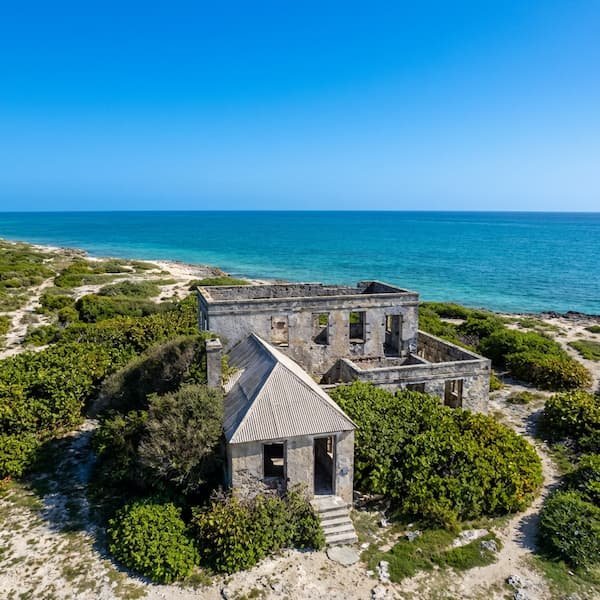
Located a short distance from Bottom Bay, the Harrismith Great House ruins overlook a reef-protected lagoon. The 1920s coral-stone structure, once owned by Roland Henry Taylor, now serves as a skeletal landmark. A set of weathered stone stairs cut directly into the cliff provides access to the beach below, which is significantly more secluded than its neighbours.
Ragged Point Lighthouse
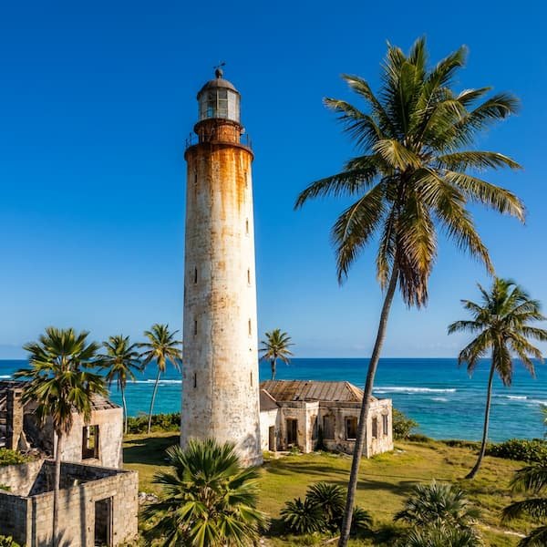
The 85-foot coral stone tower at Ragged Point was constructed in 1875 to mitigate the dangers of Cobbler’s Reef. Standing at the easternmost tip of Barbados, it provides an unobstructed view of Culpepper Island. This is a site for observation rather than activity; the Atlantic currents here are notoriously violent and unsuitable for swimming.
The Crane & Sam Lord’s
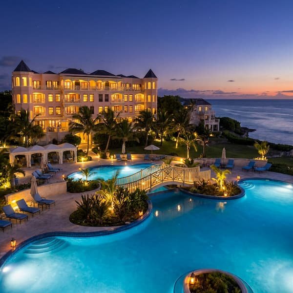
The Crane is synonymous with 19th-century luxury, featuring pink-tinged sands and a historic hotel perched on the cliff edge. Nearby, the ruins of Sam Lord’s Castle tell the legend of a buccaneer who used lanterns to wreck ships on the reef. Both locations offer a mix of high-end amenities and eerie maritime history.
Niche Regional Attractions
Shark Hole is a unique geological “spoon” carved into the limestone cliffs of a residential area in St. Philip. This tiny, circular swimming hole is only safely accessible during low tide. At high tide, the funnel-like opening in the reef cause the water to surge with enough force to overwhelm even strong swimmers. There are no lifeguards or facilities here, so visitors must carry their own supplies and exercise extreme caution.
Further east lies Ragged Point and the crossing to Culpepper Island, Barbados’ only satellite outcrop. This tiny coral island is reachable on foot only during a very low tide, though it is not a journey to be taken lightly. The Atlantic currents separating the island from the mainland are unpredictable; hikers are advised to wear reef shoes and personal life vests. For those who prefer a safer vantage point, the lighthouse offers a panoramic view of the coastline’s erosion patterns.
King George V Memorial Park serves as the primary community hub for the St. Philip parish. Gifted to the public by Major Herbert Walter Peebles, the park is adjacent to Bailey’s Plantation—the site of Bussa’s 1816 slave rebellion. It features a traditional bandstand and remains a popular site for local picnics and cricket matches, offering a domestic contrast to the wild coastal scenery found at nearby hiking trails.
Local Tip: If you are visiting Shark Hole, park at the small rocky lot nearby and walk the residential block to the hidden entrance. Do not attempt to swim if you see the water surging over the limestone ‘lip’ of the pool.
The Geology of Cattlewash
A short drive north into St. Joseph brings you to Cattlewash, a beach defined by its “mushroom” rocks. These massive limestone boulders are not shaped by wave action alone, but by intertidal invertebrates that scrape algae from the base of the rock, creating a distinct notch over centuries. The cliffs here are composed of 44-million-year-old turbidites—sediment deposits swept from the South American continent long before Barbados emerged from the ocean.
The landscape here is vast and untamed. Unlike the palm-fringed cove of Bottom Bay, Cattlewash is an open, windswept stretch of sand that feels ancient. It is a preferred spot for those seeking solitude and a place to observe the raw geological history of the island. Travelers often combine this with a visit to secluded East Coast rentals to fully immerse themselves in the quiet side of island life.
Navigating the East Coast
To experience the St. Philip coastal circuit effectively, a rental vehicle is practically essential. Public transport is available, but the frequency of service to remote spots like Ragged Point can be inconsistent. If you choose to drive, consult our guide to island navigation to understand the local roundabout etiquette and the nuances of driving on the left-hand side of the road.
For those who prefer a more local experience, the white ‘ZR’ vans operate on specific routes throughout the parish. These vans are high-energy and budget-friendly, though they rarely drop passengers directly at the more secluded cliff-top trailheads. You can find detailed route information in our ZR bus system guide. Regardless of your choice, ensure you have a physical map or an offline digital map, as cellular reception can fluctuate beneath the limestone ridges.
The Bottom Bay Residential Neighbourhood
While the beach is the primary draw, Bottom Bay is also a well-established residential enclave. The landscape above the cliffs is occupied by the Bottom Bay Development and newer projects like Atlantic Rising. These areas consist of low-density, private villas and holiday rentals, many of which follow a specific lot-numbering system. If you are navigating to a particular address, such as 213 Bottom Bay, you will find it on the elevated limestone plateau that overlooks the Atlantic. This residential zone is characterised by wide, coral-stone roads and a lack of traditional street numbering, making GPS coordinates or lot numbers essential for navigation.
The neighbourhood is strictly residential; there are no shops, pharmacies, or banks within the immediate vicinity of the development. For essential supplies, residents travel ten minutes inland to Six Roads, the commercial heart of St. Philip. The area is exceptionally quiet, though the constant sound of the ocean is a permanent feature. Security is a practical consideration for those staying in the development, as the remote location and sparse street lighting can make the area feel isolated after sunset. Always ensure villa gates are secured and avoid walking the cliff-top trails after dark.
To pinpoint exactly where Bottom Bay is in Barbados, it sits at the southeastern corner of the island, approximately 14 kilometres from the Grantley Adams International Airport. It is geographically distinct from the more sheltered southern parishes, defined by its higher elevation and the absence of large-scale hotel infrastructure. This lack of commercialisation preserves the area’s rugged character, though it necessitates a self-sufficient approach to travel.