Sargassum Seaweed: What Travelers Need to Know
⚠️Hey travelers! If you’re heading to Barbados this April (2026), I want to give you a quick heads-up. The island is currently dealing with a massive influx of Sargassum seaweed, particularly along the south and east coasts.
It’s a stubborn carry-over from 2025, and experts are predicting this season could be one of the worst on record—potentially bringing in double the usual amount. As you can imagine, this is creating some major challenges for local beach cleanup crews.
💡My top tip: Don’t let it stress you out! Just check the Sargassum Monitoring Facebook page for real-time updates so you can easily track down the clearest beaches before heading out for the day.
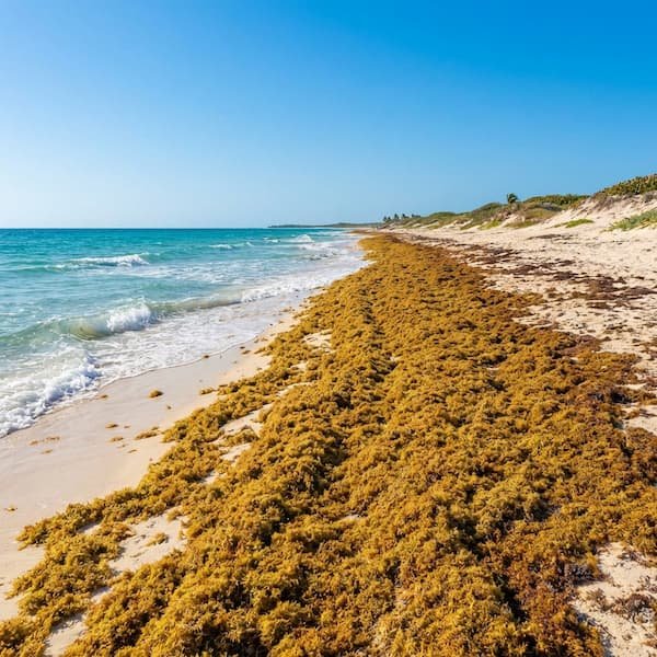
Sargassum is no longer just a seasonal guest; it has evolved into the Great Atlantic Sargassum Belt (GASB), a 5,000-mile-wide biomass that stands as the largest macroalgae bloom on Earth. For travelers heading to the rugged East Coast of Barbados to visit Bottom Bay, understanding this phenomenon is essential for managing expectations and planning the perfect beach day. While the sight of golden-brown algae on the shore can be surprising, it is a complex biological event driven by global Atlantic currents and atmospheric shifts.
The Science Behind the Bloom
This massive floating ecosystem is fueled by a “nutritional engine” of nutrient runoff from the Amazon and Congo Rivers, combined with iron-rich dust from the Sahara and ocean upwelling off West Africa. Carried by the North Equatorial Current, these mats make a direct journey toward the Lesser Antilles, with Barbados often being the first point of contact due to its easternmost position in the island chain. The movement of this belt is heavily influenced by the North Atlantic Oscillation (NAO); specific atmospheric pressure shifts dictate whether the trade winds push the seaweed directly into the St. Philip coastline or further out to sea.
| Feature | Windward Coast (Bottom Bay) | Leeward Coast (West Coast) |
|---|---|---|
| Exposure Frequency | 90% (High) | Low to Minimal |
| Current Influence | Direct Atlantic Impact | Sheltered Caribbean Side |
| Sargassum Arrival | Primary Landing Site | Occasional Drift |
| NCC Management Priority | Sub-area 3 (High Priority) | Secondary Cleanup |
Why Bottom Bay is a Primary Landing Site
The Windward Vulnerability: Because Bottom Bay sits on the easternmost edge of St. Philip, it acts as a natural catchment for Atlantic debris. Unlike the calm West Coast, the Atlantic side bears the full brunt of incoming currents, making it one of the most consistent landing spots on the island. The enclosed, cliff-side topography of the bay can sometimes cause seaweed to bank up against the coral walls, reaching heights of several feet during peak influxes.
National Conservation Management: The National Conservation Commission (NCC) categorises this stretch as “Sub-area 3”. This designation means specific resources are allocated for monitoring, though the sheer volume of seaweed can sometimes overwhelm manual removal efforts during peak bloom months. Visitors might notice “seaweed harvesters” or trucks from the SargAdapt Project, which transforms the biomass into organic compost for local Bajan farms.
The ‘Brown Tide’ effect isn’t just about the seaweed on the sand; it’s a chemical transformation of the water column itself.
The Transformation of Turquoise Waters
When large mats of sargassum linger near the shore, they leach tannins into the water, similar to how tea leaves steep in a pot. This results in a murky brown or tea-coloured hue, significantly reducing the underwater visibility that Barbados is famous for. While temporary, this aesthetic shift is a primary consideration for photographers and sightseers. Furthermore, as the algae decomposes, it releases Hydrogen Sulfide (H2S), which carries a distinct “rotten egg” scent. While usually just an olfactory nuisance, travelers with asthma should be aware that high concentrations can cause minor respiratory irritation.
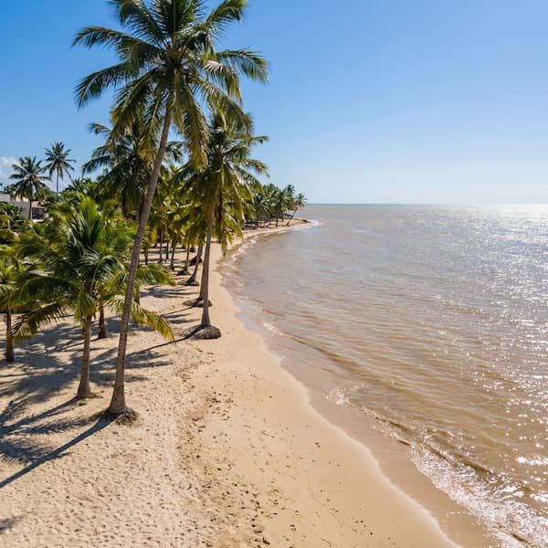
However, the sargassum is also a “mobile nursery.” Snorkelers may occasionally spot juvenile mahi-mahi—locally called Dolphin fish—and rare sea slugs sheltering within the floating gold. If the conditions at Bottom Bay are too heavy, many visitors choose to pivot their itinerary. A short drive to nearby attractions like the historic Crane Resort allows you to use their glass-fronted cliff-side elevator to check beach conditions before committing to the sand. For those seeking clear water during a “high-influx” forecast, the ZR vans can quickly whisk you toward the sheltered West Coast beaches.
Plan Your Coastal Activities
Before heading out, it is wise to consult the CERMES Sub-regional Outlook Bulletins, which provide three-month forecasts for the Eastern Caribbean. If the St. Philip coast is experiencing a heavy landing, consider booking a 6-hour coastal tour of Barbados to see which side of the island is currently offering the clearest turquoise views. Most reputable tours will adjust their routes based on current ocean safety and water clarity reports.
Sargassum Seaweed FAQ
Is sargassum seaweed dangerous to touch?
Sargassum itself is not toxic to human skin and is safe to handle, though it frequently harbors small marine life like jellyfish larvae or hydroids. These tiny organisms can cause minor skin irritation or stings, so it is generally recommended to avoid walking barefoot through thick, wet mats of seaweed on the shoreline.
What months are worst for sargassum in Barbados?
The peak “Sargassum Season” traditionally spans from **March through September**. However, **2026 has seen an unusually early onset**, with significant arrivals reported as early as January. Satellite data indicates record-high biomass levels in the Atlantic, suggesting travelers should anticipate potential “brown tide” conditions earlier than the historical average.
How long does sargassum seaweed last once it washes ashore?
The duration of an influx depends entirely on tidal shifts and manual intervention. A light scattering may wash back out on the next high tide. Conversely, major landings can bank up against the coral stone cliffs at Bottom Bay and remain for several weeks. While the National Conservation Commission attempts to clear these high-priority zones, a deep pile left to decompose naturally will take up to a month to break down completely.
Does the seaweed smell?
Freshly arrived sargassum has a mild, salty scent, but as it begins to decompose in the sun, it releases Hydrogen Sulfide and Ammonia gas. This process creates a pungent “rotten egg” odour that is most noticeable on windward beaches where the seaweed is allowed to pile up against the cliffs.
Are there any beaches in Barbados without seaweed?
During heavy bloom periods, the Leeward (West) Coast of the island almost always remains clear and turquoise because it is shielded from the Atlantic currents. Beaches like Mullins or Sandy Lane rarely experience sargassum influxes, making them reliable alternatives when Bottom Bay is heavily affected.
How can I check the current conditions at Bottom Bay?
To find out if there is sargassum in Barbados today, consult the satellite tracking maps published by the University of South Florida’s Optical Oceanography Laboratory. These provide the most reliable forecasting for the Lesser Antilles. For a real-time visual, check the live webcams at the nearby Crane Resort. Because it shares the same windward exposure, it serves as an excellent proxy for Bottom Bay. Local community groups on platforms like Reddit also frequently post daily photo updates of the St. Philip coastline. Reviewing a sargassum in Barbados today map or checking these live feeds ensures you know exactly what to expect before making the drive from Bridgetown or the Airport.
Swimming Safety and Ocean Conditions
The Atlantic swell at Bottom Bay creates a significant shore break that demands respect. While the water appears inviting, the physical conditions are often hazardous. Strong rip currents are common along this stretch of the St. Philip coastline. There are no lifeguards on duty at Bottom Bay.
The limestone cliffs reflect the sound of the crashing waves, but they also mask the strength of the undertow. Even on days when the surface appears relatively calm, the pull of the receding water is powerful. Visitors should avoid swimming alone. If you find yourself caught in a current, swim parallel to the shore until the pull weakens. Do not attempt to fight the Atlantic directly.